.png)
Exmore History Walking Tour
Exmore History Walking Tour (pdf)
Note: Using a map app on your smartphone, you should be able to hover or click on the location to get the actual street address. Unless otherwise noted, the stops on this tour are private property. Please stay on the sidewalks, when available. This tour is an overview of local history and is not intended to be all- inclusive.
Start – Southeast corner of Main Street and Bank Avenue, 3286 Main Street.
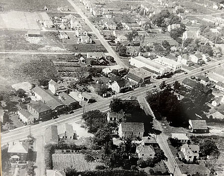
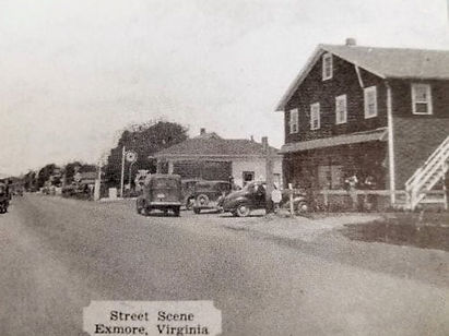
Exmore around 1930. Source: Town of Exmore
Introduction
Although Exmore was named and shaped in the 1800’s with the coming of the railroad, the town was not officially formed until 1948. The town became known as Exmore Station around 1884, which was its name into the early 20th century. The people of the Accawmacke tribes first inhabited this area, well situated between the Chesapeake Bay and seaside Barrier Islands. Once the English began patenting the land, the plantation area was granted to the Downing family and thereafter called Downingsville. WL
The time period of this tour starts in 1884 when Exmore Station opened for railway commerce. During the railroad days, Exmore became an important distribution and transportation hub due to its central location and proximity to produce and seafood producers. As you walk this tour, you will gain insight into how the construction of the railroad changed the face of America’s landscape. Small towns sprang up along railroads, just as seaports did with seaway commerce in previous eras. Most of these railroad towns were laid out by land developers that bought up farmland to sell to produce brokers, merchants, and future residents. WL
When automobiles and trucking became popular, Exmore became one of the towns on the Ocean Highway, the 1,000 mile highway stretching from US 1 in New Jersey to Florida. Main Street, also known now as Business Route 13, was part of that highway system.
Walk south on this side of Main Street
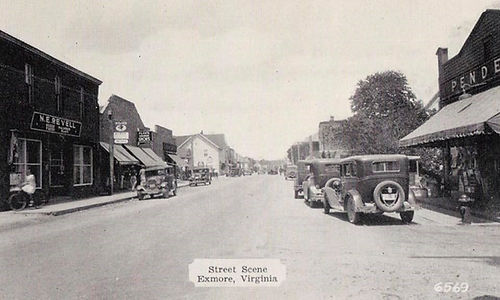
Main Street looking north. Pender’s mercantile on the right.
Stop 1 – Exmore Town Hall, 3305 Main Street
Exmore Town Hall serves 1,635 residents (2020 Census). In 1920, Exmore had 111 residents, compared to 2,517 in Cape Charles and 475 in Nassawadox. By 1960 it had 1,566 residents and then began a decline. In 2000, the Town annexed Hadlock (south of Town), the shopping centers on the Route 13 Bypass, and other surrounding areas to include properties on the town water system. This annexation bumped up the 2010 population to 1,460, a 28% increase from 2000. ES, KM
This building is open Monday through Friday during business hours. Some historic photographs are on the lobby walls.
The first Town Hall location was in the business of the first Mayor, John Mapp, on Bank Street. Town Hall over the years was moved to other locations before this current location, which previously served as the third location of Peoples Bank. Prior to this, Pender’s mercantile store was here as well as the Bagwell house and the post office (on the corner). JD
Walk South on Main Street.
Stop 2 – Estelle Freeman House, 3319 Main Street. Corner of Main Street and Commercial Avenue. Built around 1920. Across the street is 3316 Main Street, a traditional Victorian home that served as a tourist home at one time.
Now view across the street:
Stop 3 – 3312 Main Street. West side of Main Street.
This is one of the oldest commercial buildings in downtown Exmore. In the early 1900’s small wooden, boxy buildings were built in the little railroad towns that were popping up on the East Coast as rail lines were extended. Commerce grew quickly in thriving Exmore as new and larger street-facing mercantile and service stores came to town. Most of these have been replaced overtime as more substantial structures were built. Numerous businesses have located here, most recently Rancho Relaxo Restaurant, then chronologically backwards: The Yellow Duck Bakery, Sophi Andursky’s children’s clothing, and Byrd and Bundick’s mercantile. Stop 24 will describe other buildings on this block.
Continue South and Cross Willis Wharf Road. Stay on this East Side of the Street.

Chandler house, circa 1950s. Source: Joe Ortelli
Stop 4 – John W. Chandler House, 3342 Main Street. West side of Main Street.
This is private property. Please stay on the public sidewalk.
Built in 1890, the house of John W. Chandler defined the corner of Exmore Station and the road to Willis Wharf. Exmore Station was, at the time of the house’s construction, still surrounded by agricultural land. One can imagine that John Chandler chose the site of this elevated property to both make a statement about his status and to overlook the traffic on Main Street going to the railroad or on to the seaside village of Willis Wharf. The Chandler family resided at the house from 1890-1954. Chandler was the largest produce broker on the Eastern Shore of Virginia and a major landholder in Northampton County.
Chandler invested heavily in real estate acquiring most of the land within the villages of Exmore and Oyster. He is responsible for originally platting these two villages and providing economic support with his various business interests. He operated multiple businesses including oyster harvesting, fire insurance, and fertilizer manufacturing. Chandler took advantage of the proximity of the Exmore Station and Willis Wharf, and established his produce brokerage business at Exmore Station, which was then still rural, open land. The private residence is listed on the National Register of Historic Places and the Virginia Landmarks Register. DHR

Kellam’s Esso gas station
Stop 5 – Southeast Corner of Main Street and Willis Wharf Road, 3339 Main Street.
You are standing in the key intersection of town. This corner was a hub of commerce on the Eastern Shore. The vacant lot is remembered as the site of Stanley Kellam’s Esso gas station. In 1922, however, it was owned by Frank H. Abrams, a Russian Jewish immigrant.
The building to the east was Horne and Stauffer’s furniture and appliance store. This building was originally two buildings. The Occohannock Tribe No. 16, Improved Order of Red Men had a lodge on the lot east of the corner lot. It appears that this two-story section of the building was the original Red Men’s Lodge built in 1925. The Lodge was located on the second floor and the first floor was rented to Harry Benjamin to be a furniture showroom. NC. KM.
The lot to the east of the Lodge, which holds the second part of the building, was owned by Forest E. Gladden. It was likely a farm lot and residence prior to the current commercial structure being built. NC
Cross back north over Willis Wharf Road to be on the sidewalk.
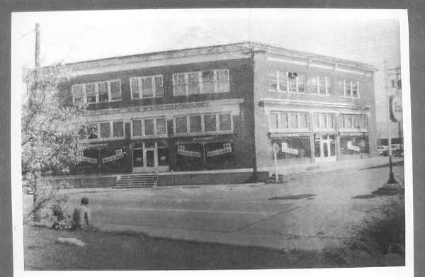
Benjamin’s Department Store, Source: Va. Dept. Historic Resources
Stop 6 – Benjamin’s Department Store, 3327 Main Street. Corner of Main Street and Willis Wharf Road.
An example of department store commerce, the building’s form and general appearance is unique in the town of Exmore and a rarity on the Eastern Shore of Virginia. The building was commissioned by John W. Chandler and operated by Harry Benjamin. Benjamin’s Department Store, later bought by Peebles, was also the first building in Exmore to have a freight elevator.
Harry Benjamin was a member of the Benjamin family that owned and operated commercial interests in Eastville and Exmore. Circa 1909, W. Benjamin took over interest in the general merchandise business of Brown and Scher, Co. located in Eastville. The company was renamed Benjamin and Scher, Co. Reviews from the Eastern Shore Herald praised the store as having the best collection of products and personalized service on the Eastern Shore. By 1912 the business was known as W. Benjamin and Son, as Mr. Scher retired to Florida. Numerous Benjamin family members were involved in the commerce established by the Benjamin family. Israel Benjamin traveled often to New York during the 1910s and 1920s to purchase merchandise to stock the stores. In 1923, Benjamin’s was incorporated. Harry Benjamin served as President, Phillip Scher as Secretary/Treasurer, and Louis Sacks as a Board Director.
On the first floor was men’s clothing, women’s clothing on the second floor, and, because of the freight elevator, appliances were on the third floor. JD
In 1975, Margaret Bell Chandler, John W. Chandler’s second wife, formally sold the building to Peebles Department Store, Inc. The store remained open until it relocated to Onley around 1984. The privately-owned building is listed on the National Register of Historic Places and the Virginia Landmarks Register. DHR, AI
Walk east on Willis Wharf Road

Central Hotel. Source: David Scanlon
Stop 7 – Lot behind Benjamin’s (Peebles)
This was the site of the second business started in Exmore, a store owned by Ewell Nottingham. This was later the site of the Central Hotel. The building survives today. It was cut in half and became two houses that were moved to addresses 11614 and 11592 Occohannock Road. The town’s livery stable was likely here before the hotel. HE. JD.
Continue east toward RailTrail. Stop 8 is a grassy area.

Willis Wharf’s. Source: Curtis Badger Collection at ESVA Heritage Center
Stop 8 – Corner of Willis Wharf Road and Front Street
Willis Wharf Road derives its name from the seaside village 1.5 miles east of here. Willis Wharf was also called Downing’s Wharf and Bigelow’s Wharf. It remains an important distribution and aquaculture industry harbor. Exmore station was placed here by the railroad to provide direct access from and to Willis Wharf.
The Eastern Shore of Virginia was primarily agrarian in nature during the late 19th and early 20th centuries. Before the coming of the railroad, produce was shipped via boat to major harbors such as Norfolk, Baltimore, and other points north. The southern climate of the Eastern Shore brought produce to market earlier in the season than northern farms. This enabled Eastern Shore farmers to provide locally grown crops to northern markets during peak pricing periods. The steamship and sailing craft provided adequate transportation of goods to port towns in the north. In addition to locally grown produce, seafood harvests such as oysters were also a profitable
market. This symbiotic relationship between northern markets and southern farms was beneficial throughout the late 19th and early 20th centuries.
Since the primary mode of transportation was via water routes, most towns in Northampton County were located on either side of the peninsula. Prior to the opening of the railroad, there were few inland towns. The New York, Pennsylvania, and Norfolk (NYP&N) Railroad was formed and began acquiring land along its proposed route in 1883.
The original plan was to parallel the Seaside or Bayside Roads, but the placement of the line was roughly between the two roads. In some places, it was located to serve significant 19th century towns, such as Eastville, the Northampton County seat. The route chosen by the NYP&N Railroad was the east or seaside route that paralleled the Seaside Road or the present-day US Route 13. The reorientation of the railroad and its planned stops produced new villages. Developers like John W. Chandler recognized the value of investing in properties and plotting railstop towns.
Eight miles southeast of Willis Wharf, by water, is Hog Island, home to a fishing community of over 300 people until the 1933 storm washed away many of this barrier island’s houses. Its residents would have enjoyed shopping the many stores of Exmore.
Stop 9 – M.J. Duer Offices, 12135 Commercial Ave. Duer was one of Exmore’s largest produce brokers. Other brokers included John Mapp, C.J. Prettyman, and A.R. Ashby.
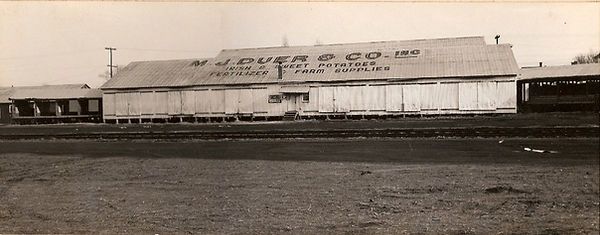
One of Duer’s Packing Houses, circa 1956. Source: ESVA Heritage Center ESVA Photograph Collection
Stop 10 – M.J. Duer Packing House. Corrugated metal building across the tracks and grassy field. The grassy area between the tracks and the packing house held railroad side tracks, called team tracks. Shippers and farmers could load and unload freight cars parked on these tracks. Beyond the packing house is one of the historically African American residential communities. Exmore was one of the largest employers on the Eastern Shore, providing employment for African Americans on the railroad, at Dulany’s food processing plant, and other thriving businesses. Like many Southern small towns, Black people were marginalized, residing outside of the town limits until integration.
Continue North on Front Street.
Stop 11 – “The Bean House,” 12141 Commercial Ave. Today Front Street seems barren with numerous vacant lots, but during the railroad days, it was a center of commerce with various storage, small store front, and shipping buildings. The wood building on the corner of Commercial Avenue and Front Street, was a bean storage shed for M.J. Duer. 3315 Front Street, was moved here from Accomack in 2006. A small building on the corner was removed to another location. This is a reminder that buildings do move around in addition to being demolished.

The second station. Source Town of Exmore.
Stop 12 – Exmore Railway Station. East side of Front Street.
This is the site of Exmore Station, Number X (10), on the NYP&N Eastern Shore line. The original 1885 station was demolished in 1905. The original station house was two stories, whereby the station agent and his family lived upstairs. Its one-story replacement lasted until around 1990. Thereafter, the current building, which was the Belle Haven station, was moved here.
A deed between the NYP&N Railroad and Orris A. Browne in 1893 refers to the acquisition of a strip of land along the railroad that was purchased for the construction of a spur. Orris A. Browne owned land on either side of the railroad at Exmore, which was called the Yeatman Lot, though there is no reference to a station. The sale of this strip may have also been an attempt by the railroad to construct a station house.
Not only was the station used to ship produce and seafood, but it also served to transport passengers. Many Northerners came to Exmore to go hunting and stayed at the lodges on the Barrier Islands, such as Hog Island. President Grover Cleveland came here several times.
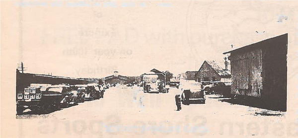
Exmore Produce blocks. Source: ES News, 7/10/85
Stop 13 – Looking North up Front Street, formerly Pennsylvania Avenue.
Exmore soon grew beyond a rail station for shipping produce to a host for produce packing businesses, most notably J.H. Dulany and Sons freezing plant, built in 1938. The Fruitland, Maryland company was wooed by the Exmore Business Men’s Club to locate on this five-acre property. Now demolished, this frozen food plant was the first plant built by Dulany solely for freezing produce. Its product bore the Birds Eye label and, later, its own Dulany label. The business thrived during World War II when tin canning supplies were scarce. By 1950, Dulany’s employed 400 people, making it the largest employer in town. In 1975, Dulany’s was sold to Exmore Foods, which operated until 1980.
Also on this street was the Eastern Shore Public Service, which supplied electricity to the town. In 1915, the Exmore Ice and Storage Company was incorporated, on the corner of Front and Mapp Streets. Its cold storage capacity grew to 10,000 barrels with a 40 ton daily ice-making capacity. In 1913, this company organized the Exmore Light and Power Company. Both the ice and power plant later were sold to Eastern Shore Public Service Company of Maryland, which, in turn, became part of Delaware Power and Light, later known as Delmarva Power.
Nearby was the Chandler Fertilizer Company, built in 1930, by John W. Chandler. It used imported Peruvian guano in production. It was built by John W. Chandler. ES, KM, NC.
Also nearby were the “strawberry blocks” where farmers sold their fresh produce to the brokers. On this corner stood a large pool hall. It may have had a Masonic Temple upstairs. JD

Source: ESVA Heritage Center
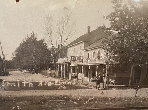
Shield’s Hotel, Source: David Scanlon
Note Bank Street called Smith Avenue then, mostly houses.
Stop 14 – Shield’s Hotel, 12147 Bank Ave. In 1884, Benjamin Upshur Doughty (1842-1925) erected a house here. He operated a bar in it and a livery on the property. The next year, Thomas West of New Church bought the house and bar, then enlarged it into a hotel. Doughty returned to operating it by 1900 and enlarged it again. The hotel ended up being three stories. The hotel stayed in the family as Doughty sold it to his daughter Annie and her husband Garland Chandler. After Garland’s death in 1917, Annie ran the hotel until 1956. The hotel included a livery. The hotel’s name changed to the Exmore Hotel sometime before 1920. It was demolished in early 1958 and its wood repurposed for local houses. HE, GVES, KM
Walk West on Bank Street, back toward Main Street.
Stop 15 – Tip Top Market (now vacant lot) 12148 Bank Ave. On the east side of the current antique store stood the Tip Top Market, previously owned by Rudy Brady and then Harvey Killmon’s Market. It then became Ruth’s Consignment Shop before being demolished. DS, JD

Benjamin Upshur Doughty (1842-1925). Source: Jerry Doughty
Stop 16 – Benjamin Upshur Doughty, 12144 Bank Ave. Prior to this structure, the home of Benjamin Upshur Doughty (1842-1925), owner of the Shield’s hotel, stood here. He was a boat builder from Hog Island, known for building the fastest boat in the area, the “Janie” racing bateau, named after his wife, Elizabeth Jane Bonnewell Doughty. The April 19, 1890 Peninsula Enterprise reads: “CHALLENGE -- The skiff 'Bet Wise' will sail the skiff 'Janie' for a purse of $200 -- and the friends of the latter must put up or shut up. Polk Lang, Accomac C. H., Va.” Doughty owned Shield’s Hotel at one time. His daughter sold pastries out of the house. JD, VC
The first Exmore post office was opened on December 12, 1884 and was located near here. For a brief time, the post office was located on Broad Street and then Main Street, but later moved back to Bank Avenue. The current location was built around 1960. HE During the days of the active railway, mail was delivered twice a day to Exmore.
Stop 17 – Western Union, 12138 Bank Ave. This small red brick building was constructed in 1910 by M.J. Duer & Co. and served as a Western Union location until 1960. The telegraph line originally ran to the train station. Produce dealers and Willis Wharf fish companies needed the telegraph services until telephones became commonplace. To the right of 12138 stood the Bagwell House.
Stop 18 – North side of Bank Avenue. – Residential houses, now gone, mostly lined this street. Existing buildings include Paul Shrieves Barber Shop (12125 Bank Ave.) and Doughty’s, later Poulson’s, Cleaners (12129 Bank Ave.), and Elliott’s Furniture (12133 Bank Ave). Charles Lankford’s, namesake of Route 13, had his law office on this street as did Dr. Leroy Johnson, a veterinarian. JD

Main Street view east from municipal parking lot of
1916 Peoples Bank and Ashby’s (later Lloyd’s) Drugstore.
Stairs to the Apollo Theatre showing. Source: David Scanlon
Stop 19 – Peoples Bank, 3291 Main Street – Peoples Bank, chartered on June 28, 1916, was originally on the corner (where the flagpole is) as a small, angular brick bank building, most typical of early banks on the Shore. L.E. Mumford Bank originally occupied the now demolished brick bank, prior to Peoples Bank. The Peoples Bank Directors, all from Exmore or Willis Wharf, were: William E. Walker (President), E.L. Robins (Vice President), George T. Jarvis, William E. Johnson, Thomas O. Twyford, James E. Turner, and J.W. Savage. E.D. Broun of Cape Charles was Secretary. The bank was moved to this larger building around 1957 and featured a drive-thru service window. It later moved to 3305 Main Street (current Town Hall). Peoples Bank ceased operation in 1984, being acquired by First Virginia Bank, now Truist. JD, NC
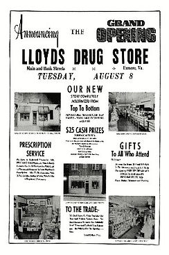

Lloyd’s in the two story Bank Street building. Source: Eastern Shore News
Stop 20 – Ashby’s/Kellam’s Drug Store & Apollo Theatre, 12125 Bank Ave. (parking lot) – This was the original site of Lloyd Kellam’s father’s drug store before a new one was built across the street around 1968. The two-story building housed the Apollo Theatre, which showed silent movies, on the second floor and Ashby’s Pharmacy on the first floor. Pharmacies had ice cream and snack bars and were also popular for their comic book selections. Lloyd Kellam, Sr., a businessman from Cape Charles, bought out Ashby’s and opened this pharmacy in 1950. Another prior co-tenant was J. Morris Young and The Pastry Shop. The concrete block building was demolished after the move to the new Lloyd’s Drugstore. JD, KM, LK
In addition to being a traditional drugstore, Lloyd’s also served as a popular gathering place with its soda bar and grill. Proprietor Lloyd Kellam was an equal opportunity employer long before the concept was established. He took special pride in giving many young people their first job. Kellam was also proud to be the first Northampton County merchant to serve African Americans at his lunch counter. Lloyd’s was also a stop for the Greyhound and Trailways bus companies. As railway public transportation faded, buses became an important means of transportation for Eastern Shore residents. Frequent travelers like Arthur "big Boy" Crudup, depended on buses for travel. Crudup was an African American musician & songwriter sometimes referred to as one of the "fathers of Rock 'N Roll."
Cross to the north side of Bank Avenue
Stop 21 – Clara Mapp Tourist Home Boarding House, 3271 Main Street – Prior to the 1968 construction of Lloyd’s Drugstore, a tourist home was located here. Tourist homes, generally 10 rooms or less, were popular for travelers in small towns along the Ocean Highway and for railroad passengers, drummers, and businessmen. Potato inspectors at Exmore’s busy produce businesses were in need of such accommodations. Clara Hudson Mapp was the wife of Arthur Downing Mapp, a descendant of Arthur Downing, owner of a large area of property called Downingsville and the namesake of Downing’s Wharf, later called Willis’s Wharf. Besides 3271 and 3316, it is believed that 3212 Main Street also served as a tourist home. The Mapp tourist home was torn down to build a larger building to accommodate Lloyd drugstore’s growing business.
Walk north on Main Street

Looking north on Main Street. Source: David Scanlon
An earlier view.Source: Barry Mears
Stop 22 – East Side of Main Street - Past businesses located on this block included:
-
3263 Main St - Benjamin Franklin, (which later moved to 3306 Main St.), then Elliott’s furniture, which moved from 3280 Main St.
-
3249 Main St. – VFW. Was Bill Prince’s “The Roost” restaurant.
-
3229 Main St. – Now Liv’s. Was Bill Justis and then “Toothpick” Parkerson’s Texaco. It also served as a town library briefly in the 1990’s. Another library was in Exmore in the early 1900’s, but it’s location is unknown.
-
3223 Main St. - Wilkins Brothers Garage, which was originally at 3292 Main Street.
Cross to the west side of Main Street
Stop 23 – West Side of Main Street, North of Westfield Ave. – Past businesses included:
-
3254 Main St. - Revell’s jewelry store. The vacant lot to the left was Revell’s Hardware store and then Burton’s Supply. This was a two story wood building that burned.
-
3264 Main St. on right - a shoe store and then Awful Arthur’s Pizza and Sub Shop.
-
3264 Main St., middle - Cameo Theatre. On July 7th, 1938 the Cameo Theater opened with a showing of “Stage Door” starring Katherine Hepburn and Ginger Rogers. It operated until around 1956. Other occupants included a roller rink, a mini-nightclub, Meatland’s corporate offices, and New Ravena. PIF, JD, LK, DS
-
3264 Main St., on left - Exmore Rexall Pharmacy, also known as Brick Tankard’s Pharmacy. This was later the Montgomery Ward dealer and Lusby’s Appliance store.

Officer Luby “Holley” Hollandsworth. Source: David Scanlon
Stop 24 – West Side of Main Street, South of Westfield Ave. – Past businesses included:
-
3270 – E.M. James Shoe Store
-
3276 - Marion’s Dry Goods, Silco general store, and Dollar General. New Ravenna now occupies it.
-
3280 – Wallace’s general store. Now vacant.
-
3282 - Custis’ Record Shop. Now an antique store.
-
3292 – Wilken’s Texaco gas station, later an insurance company and The Pastry Shop. The Pastry Shop was one of four based in Onancock.
-
3298 - Currently Seashore Eyecare; previously Flax’s, then Freedman’s, then Glick’s clothing store. Saul Glick, another Russian immigrant and an Onancock merchant, opened his second store here. A&P grocery and later Elliot’s Furniture were here.
-
3304 - Ben Franklin. Now Exmore Antique Emporium.
-
3306 – Revell’s. Unclear if original sight of hardware store.
-
3312 – See Stop 3. This location has been many different businesses, most recently restaurants.
-
3316 - Otho Byrd had an open-air farmer’s market and later built this brick building, Byrd’s Produce Market. His wife had a gift shop next door at 3312.
-
3322 - This duplex store front was many things over the years, including the first Custis’ Record Shop.
End of tour.
Thank you for exploring the history of Exmore! We hope you will stay and visit our shops and fine eateries. To learn more visit https://www.exmore.org/visitors.
Researched and written by Cara Burton and James L. McDaniel with help from the following sources:
AI – Articles of Incorporation for Benjamin’s
DHR – Virginia Department of Historic Resources
DS – David Scanlon
ES – Northampton County: Economic and Social, UVA Record Extension Series, 1927
GVES – Glimpses of a Vanished ES, Kirk Mariner
HE - History of Exmore brochure. Mariner Collection
JD – Jerry Doughty interview
KM – Kirk Mariner Collection, ESVA Heritage Center
LK – Lloyd Kellam
NC – Northampton Court records
PE – Peninsula Enterprise
PIF - Virginia Department of Historic Resources, PIF Resource Information Sheet
VC – Virginia Chronicles, Library of Virginia
WL – Whitelaw’s Virginia’s Eastern Shore
Recommended reading:
Federal Writers’ Project of the Works Progress Administration, American Guide Series: The Ocean Highway, New York: Modern Age Books, Inc., 1938.
Curtis Badger’s books on the Eastern Shore. Various titles include lots of photographs. E.g. Images of America: Northampton County. Arcadia Publishing.
“Countryside Transformed” – A collection of articles and photographs that document how the railroad changed the the Eastern Shore. https://esplheritage.org/home-esva-heritage-center/learn/collections/digital-collections/